3D Spaces in Minutes: Revolutionizing Property Digitization with Hesai Lidar
For realtors, developers, and businesses, creating accurate digital representations of large properties—known as digital twins—used to be a time-consuming, labor-intensive process. Days of manual measurements were required to capture layouts, depth, and distances accurately. Today, advanced lidar technology is transforming the way we digitize spaces—making it faster, easier, and more precise than ever.
The challenges of spatial digitalization
Traditional digitization often depends on staged environments and multiple camera setups with limited fields of view. This makes mapping multiple large spaces time-consuming and labor-intensive. Cameras also struggle with depth accuracy, producing visually appealing tours that are ultimately unusable for CAD modeling or construction.
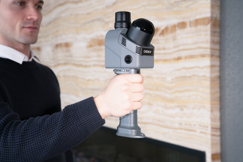
Hesai’s XT series high-precision lidar solves these challenges with a 360-degree field of view using just a single unit. Lightweight and compact, it supports handheld, mobile mapping workflows, allowing operators to scan freely without tripods, capturing every critical detail with precision.

Key features of Hesai’s XT series lidar
Outstanding performance: Hesai’s XT series delivers precise spatial measurements from up to 120 meters away, making it ideal for scanning large-scale environments such as warehouses, convention centers, auditoriums, or indoor stadiums. It generates dense, high-precision point clouds with a point rate of up to 320,000 points per second. This enables accurate 3D reconstruction in a fraction of the time. A full scan can take as little as four minutes, with CAD files ready in as little as 15 minutes.

Millimeter-level precision: With its 5 millimeter precision, the XT series delivers robust, highly detailed spatial digitalization. It captures fine-grained details such as wall edges, small fixtures, and floor textures that lower-precision systems often miss. This level of accuracy is essential for applications like interior design, industrial facility mapping, and Building Information Modeling (BIM), ensuring walls, fixtures, and floor textures are captured accurately, saving time and preventing costly errors in design or construction.

Minimum range of zero: Another key feature of the XT series is its minimum range of zero. It can perceive entire spaces thoroughly, even if an object is in direct contact with the sensor. Operators can walk right up to an object or wall while scanning. This complete spatial capture with minimal effort maximizes accuracy and efficiency, speeds up workflows, and reduces labor time and cost. Combined with its high precision, it improves object recognition and classification. In cluttered environments such as warehouses or factories, this helps differentiate closely spaced objects, reducing misclassifications or missed detections.

Whether it’s XT series’ performance, high precision, or minimum range of zero, these advantages deliver tangible value across commercial, infrastructure, and industrial applications. With accurate 3D perception, property owners no longer need to manually measure distances—they can confidently plan layouts, purchase furniture, and execute renovations with greater accuracy. This leads to more informed decision-making, fewer costly errors, and faster design-to-build timelines, keeping projects on track from day one.
As a global leader in high-precision 3D modeling perception, Hesai has the highest market share in the spatial sensing market driven by continuous innovation and excellent product performance. To date, Hesai’s XT series has been successfully shipped to 19 countries worldwide.
JT128: compact, affordable, and powerful
With Hesai’s vertical integration and in-house mass production capabilities, the company is leading the democratization of spatial digitalization by significantly reducing the cost of lidar without compromising quality. Demonstrating this shift is Hesai’s JT128, a mini hyper-hemispherical 3D lidar, which features an ultra-wide 360° × 189° field of view—delivering full coverage with zero blind spots.

The JT128 hits a sweet spot between functionality and portability. With a 70% smaller volume compared to similar products and weighing just 250 grams, it’s easy to integrate into mobile workflows.
Despite its compact size, the JT128 delivers an impressive 1.15 million points per second. It’s ideal for short-range digitalization tasks where detail and accuracy matter, offering excellent performance and ROI. Built on Hesai’s 4th-generation automotive-grade ASIC architecture and backed by over 100,000 cumulative deliveries, the JT128 is a proven, reliable solution for high-volume deployment.
Together, these advantages make the JT128 ideal for small to mid-scale spatial digitalization. Its compact design, reliability, and affordability open the door for businesses of all sizes—and even consumers—to adopt lidar-powered digital twin technology.
The growing reality-capture market
According to GlobalData, the digital twin market is expected to grow rapidly—from USD 5 billion in 2019 to USD 154 billion by 2030. In real estate, lidar enables precise floor plans and virtual walkthroughs for renovations and remote marketing. Museums and cultural exhibitions benefit from immersive virtual tours, while warehouses gain optimized layouts, AGV navigation, and streamlined operations.
With Hesai’s XT & JT series lidar solution, businesses and creators can bring any space into the digital world with unprecedented precision and speed—unlocking new opportunities for design, planning, and immersive experiences. The future of smart, data-driven spaces is here, and it’s powered by lidar.