From Data to Understanding: How Lidar and Spatial Intelligence Reveal What Traditional Traffic Data Systems Misses
Accident reports tell road authorities where accidents happened.
They do not show where the next accident is most likely to happen.
The same challenge exists across infrastructure operations. A parking operator may know how many spaces are occupied without understanding how the facility is actually being used. A motorway operator may have access to traffic volumes and speeds without seeing the behavioral patterns behind emerging congestion. An airport may know passenger numbers without fully understanding how people move through terminals throughout the day.
In each case, the missing piece is context.
Traditional traffic data systems are designed to detect events, record measurements, and generate alerts. They provide valuable information, but often leave operators with an incomplete picture of how people, vehicles, and infrastructure interact in the real world.
This is where spatial intelligence is changing the conversation.
By combining Hesai’s high-resolution lidar technology with AMORPH’s full-stack spatial intelligence platform, operators can transform movement data into actionable operational intelligence, enabling a continuous understanding of how people, vehicles, and infrastructure interact in real-world environments.
Hesai lidar sensors provide the detailed three-dimensional view of the environment. AMORPH transforms that perception into operational intelligence by reconstructing trajectories, analyzing interactions, identifying conflict situations, and uncovering patterns that conventional detection-based systems often miss.
The result is not simply more data.
It is a better understanding of how an environment actually functions.
Understanding What Happens Between Events
At a busy intersection in Papendrecht, Netherlands, thousands of interactions take place every day between vehicles, cyclists, and pedestrians.
Most never appear in an accident report.
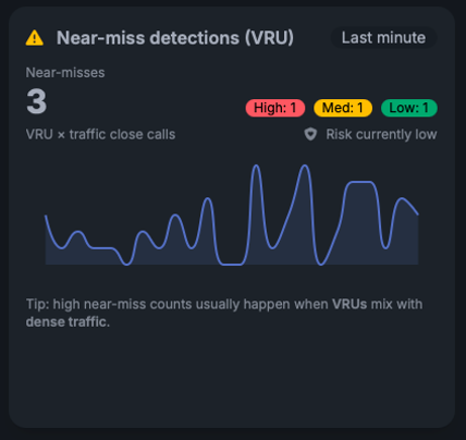
Near-miss detection dashboard identifying interactions between vulnerable road users (VRUs) and vehicles in real time, helping operators detect emerging safety risks before accidents occur.
A cyclist brakes unexpectedly to avoid a turning vehicle. A pedestrian changes direction after misjudging a traffic gap. Drivers repeatedly approach a crossing in a way that creates conflict with vulnerable road users.
Taken individually, these moments may seem insignificant.
Taken together, they reveal how an intersection actually operates.
The City of Papendrecht wanted to gain a better understanding of these interactions. Traditional traffic studies and accident statistics provided part of the picture, but neither offered continuous visibility into what happened between incidents.
To address this challenge, the city deployed AMORPH’s spatial intelligence platform, powered by Hesai lidar sensors and complementary sensing technologies.[1]
The system continuously tracks vehicles, cyclists, and pedestrians, reconstructs trajectories, and identifies near misses, conflict situations, and recurring behavioral patterns in real time. Instead of relying solely on historical outcomes, operators can observe how infrastructure is being used and evaluate whether changes are having the desired effect.
The deployment enables continuous 24/7 spatial perception, providing operators with a level of visibility that would be impossible to achieve through periodic traffic studies alone.
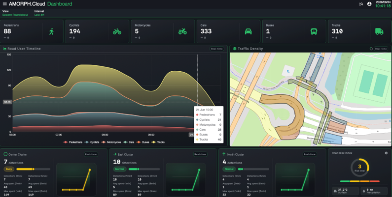
The AMORPH.senses dashboard provides operators with a real-time overview of traffic activity, road user classification, traffic density, and safety indicators, transforming raw lidar data into actionable operational intelligence.
The same principle applies beyond intersections.
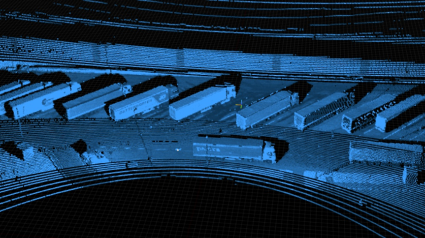
In Germany, truck parking operators are using the technology to understand how vehicles move through parking facilities, how capacity is utilized, and where operational bottlenecks emerge. Occupancy data tells operators whether a space is occupied. It does not explain how the facility is being used.
Image description – Truck parking management solution in Germany, combining Hesai lidar with AMORPH.senses to analyze vehicle movements, parking occupancy, and site utilization in real time, helping operators improve efficiency and optimize available capacity.
Motorway operators are applying the same approach to understand traffic behavior across larger sections of roadway. Traffic volumes describe what passed a measurement point. They do not explain how traffic behaves between those points.
Different environments.
The same underlying challenge.
Understanding behavior rather than simply recording events.
Why Perception Quality Matters
Behavioral intelligence depends on perception.
To reconstruct trajectories, measure interactions, identify near misses, or analyze traffic dynamics, operators need an accurate representation of what is happening within an environment.
That is where lidar plays a critical role.
Hesai lidar sensors provide a precise three-dimensional view of vehicles, cyclists, pedestrians, and other objects moving through space. This level of detail creates the foundation for the analysis that follows.
Without accurate perception, it becomes difficult to reliably understand interactions or identify meaningful patterns. With it, operators gain a much richer view of how environments function and how conditions change over time.
AMORPH builds on this perception layer by transforming movement data into actionable operational intelligence, helping operators move from observation to understanding.
Unlike many solutions that focus on a single layer of the technology stack, AMORPH provides an end-to-end platform covering sensor planning, deployment, perception, behavioral analytics, visualization, and operational decision support. This enables infrastructure operators to move seamlessly from data collection to actionable decision-making within a single platform.
Together, the two technologies address a challenge that many infrastructure operators face today: not a lack of data, but a lack of understanding.
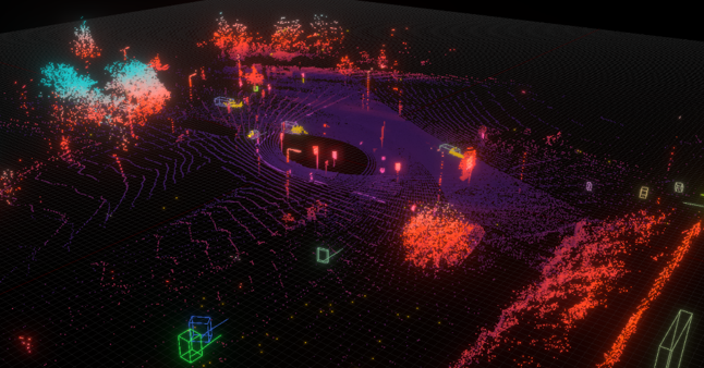
Smart intersection deployment in Papendrecht, Netherlands, where Hesai lidar and the AMORPH.senses platform continuously analyze interactions between vehicles, cyclists, and pedestrians to identify near misses, conflict zones, and behavioral patterns in real time.
Beyond Roads and Highways
While transportation infrastructure provides a clear example, the same approach is being applied in a growing range of environments.
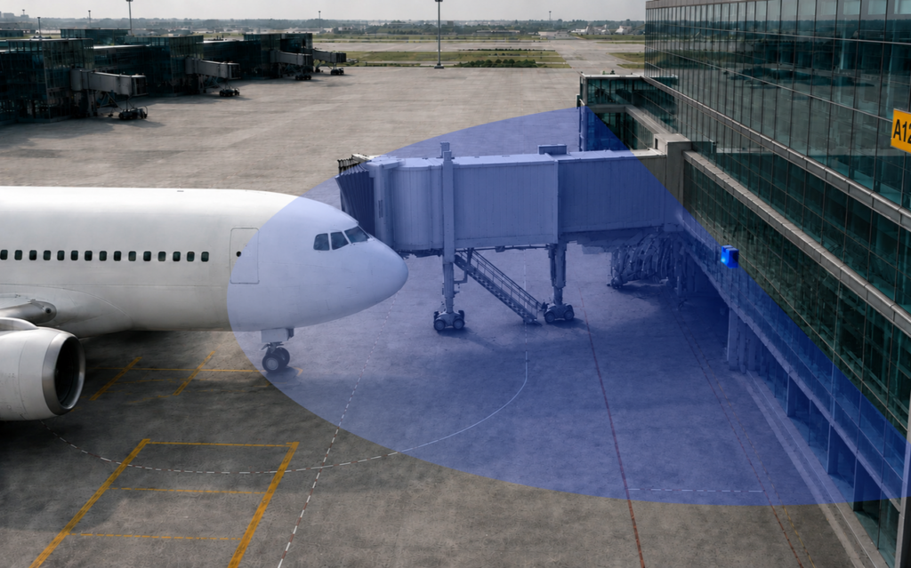
Airports are exploring new ways to understand passenger movement, queue formation, and operational bottlenecks. Event organizers seek better visibility into crowd behavior and movement patterns. Critical infrastructure operators require reliable intrusion detection and perimeter awareness.
The environments differ.
The objective does not.
Understanding how people and assets behave within a space often provides more value than simply detecting that they are present.
That is where spatial intelligence creates value.
From Data to Understanding
For decades, infrastructure operators have relied on systems that count vehicles, detect objects, measure speeds, and record incidents.
Those capabilities remain essential.
What is changing is the expectation of what infrastructure data should deliver.
Knowing that an event occurred is valuable.
Understanding the behavior that led to it is often more valuable.
The examples from Papendrecht, German truck parking facilities, motorway networks, and emerging airport applications illustrate what becomes possible when high-quality lidar perception is combined with spatial intelligence.
For Hesai, it demonstrates how lidar is enabling a new generation of applications that extend well beyond traditional detection-based systems.
For AMORPH, it is an opportunity to transform movement data into operational understanding.
And for infrastructure operators, it offers something increasingly important: the ability to identify patterns, understand behavior, and make decisions based on how an environment actually functions rather than how it appears in a report.
Most infrastructure systems were designed to tell operators what happened.
Spatial intelligence adds something different.
An understanding of how and why it happened.
Frequently Asked Questions
What is spatial intelligence?
Spatial intelligence combines sensor data, analytics, and visualization tools to understand how people, vehicles, and objects move and interact within a physical environment.
What does AMORPH do with lidar data?
AMORPH transforms lidar data into operational intelligence by tracking movement, reconstructing trajectories, analyzing interactions, identifying conflict situations, and generating insights that help operators understand how an environment functions.
Why use lidar instead of traditional traffic data systems alone?
Traditional systems often focus on counts, occupancy, incidents, or measurements at specific points. Lidar provides detailed three-dimensional information about movement and interactions across an entire environment, enabling a deeper understanding of behavior.
What are examples of spatial intelligence applications?
Applications include smart intersections, traffic safety analysis, motorway analytics, truck parking management, airport passenger flow analysis, crowd movement intelligence, intrusion detection, and infrastructure performance analysis.
How can spatial intelligence improve road safety?
By continuously analyzing interactions between vehicles, cyclists, and pedestrians, operators can identify conflict zones, recurring risk patterns, and near misses before they appear in accident statistics.
Is this approach privacy-friendly?
Yes. The focus is on movement and interactions rather than identifying individuals, helping organizations generate operational insights while supporting privacy-conscious spatial intelligence practices.
Source
[1] AMORPH Smart Intersection Case Study – Papendrecht, Netherlands
Link: https://amorphsenses.com/traffic-safety-vru-smart-intersection-lidar/
About the Collaboration
AMORPH’s spatial intelligence platform combines lidar and complementary sensing technologies to generate operational intelligence from complex environments. Hesai lidar sensors provide the high-resolution perception layer, enabling accurate tracking, trajectory reconstruction, interaction analysis, and behavioral understanding across transportation networks, mobility hubs, airports, public infrastructure, and other large-scale environments.
Link: https://amorphsys.com/