Construction Decisions Are Only as Good as the Reality They’re Based On – How Lidar Enables Reliable Construction Digital Twins
Every construction project generates drawings, BIM models, photos and reports. Yet one simple question often remains difficult to answer:
What does the site actually look like today?
Construction decisions are only as good as the reality they are based on. Outdated drawings, fragmented documentation and infrequent site visits increase the risk of delays, rework and costly mistakes. The challenge is rarely a lack of data. It is ensuring everyone works from the same accurate, up-to-date view of reality.
A digital twin is only as valuable as the data used to build it. Without accurate and repeatable reality capture, even the best digital model quickly becomes outdated. This is the challenge Inkers set out to solve.
Inkers is an India-based construction technology company specializing in reality capture and digital twins. Its solutions help owners, contractors, engineers and facility managers create continuously updated digital representations of projects throughout their lifecycle. To date, the company has processed more than 16,000 scans and digitized over 450 million square feet across construction, infrastructure and industrial projects.
By combining its LITHIC Pro handheld reality capture system with the Observance platform, powered by Hesai’s XT32 lidar, Inkers enables teams to compare planned and actual site conditions, identify deviations earlier and make decisions based on measurable site data.
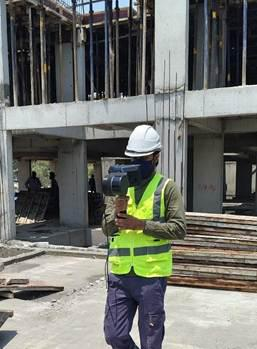
LITHIC Pro in action on a live construction site, enabling a single operator to capture high-accuracy 3D data without disrupting ongoing work.
Why lidar matters
Digital twins do not create accurate project information on their own. They depend on accurate reality capture.
Construction sites present demanding conditions for 3D perception. Structures change constantly, lighting conditions vary and complex mechanical, electrical and plumbing systems create highly detailed environments. Camera-only and photogrammetry-based approaches can struggle to deliver the consistent geometry required for engineering applications.
Lidar directly measures three-dimensional space, producing accurate point clouds regardless of lighting conditions. This provides the reliable geometric foundation needed for scan-to-BIM, deviation analysis, quantity verification and digital twin creation.
For LITHIC Pro, Inkers evaluated multiple lidar options before selecting Hesai’s XT32. The sensor combines high point cloud density, automotive-grade reliability, compact dimensions and consistent indoor and outdoor performance, making it particularly well suited for handheld reality capture on demanding construction sites.
This combination enables detailed, repeatable reality capture for everyday field use. In typical deployments, a single operator can capture approximately 50,000 square feet in around 30 minutes, making frequent reality capture practical rather than limiting it to occasional surveys.
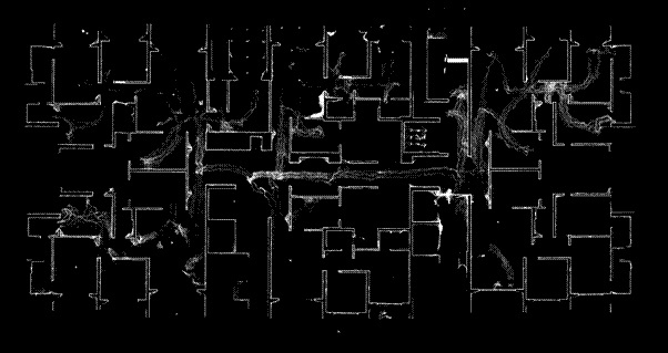
High-density point clouds generated by Hesai XT32 provide the accurate geometry required for scan-to-BIM, engineering documentation and deviation analysis.
From reality capture to project intelligence
Every project starts with BIM models, design drawings and schedules. As construction progresses, however, engineers, contractors, subcontractors and owners contribute information through different tools and workflows. Progress updates and documentation quickly become fragmented, making it difficult to maintain a consistent view of actual site conditions.
Accurate reality capture changes that. Instead of relying on periodic snapshots, project teams can compare the physical site with the digital plan using measurable, up-to-date data. This creates a shared view of reality that supports faster decisions, better collaboration and earlier identification of deviations.
LITHIC Pro captures accurate 3D site data, while Observance transforms it into digital twins, as-built BIM models and project intelligence. The platform supports progress verification, quantity analysis and quality assurance, allowing project teams to compare planned and actual site conditions using measurable site data rather than manual reports or fragmented documentation.
Instead of relying on disconnected documents, spreadsheets and periodic site visits, owners, contractors and engineers can work from the same continuously updated representation of the project. The result is a shared understanding of the project that supports better decisions throughout planning, construction and long-term asset management.
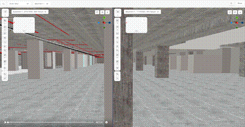
Observance’s comparison view allows project teams to compare BIM models and captured reality, making design changes and construction progress visible in a single interface.
Real-world applications
- Airport infrastructure
At a major commercial airport, engineering teams needed accurate as-built models before integrating a new baggage handling system. Existing drawings were outdated, while complex mechanical, electrical and plumbing systems made conventional surveying slow and difficult.
Using LITHIC Pro powered by Hesai XT32 lidar, Inkers captured approximately 200,000 square feet of terminal space while airport operations continued uninterrupted. Site capture was completed in less than 15 days, compared with approximately 90 days using conventional workflows.
Validated scan-to-BIM deliverables were completed in about three weeks instead of the typical three months, providing engineering teams with a trusted digital baseline for future upgrades, maintenance and expansion.
- Commercial construction
On a 1.1 million square foot commercial development, the owner wanted to align billing, quantity verification and quality assurance with actual site progress from excavation through project handover.
Regular reality capture enabled objective verification of progress, quantities and quality throughout construction. Point cloud-based volume calculations supported excavation and fill verification, while comparison of planned and actual site conditions helped identify deviations earlier and improve transparency across project stakeholders.
Teams could continuously compare design intent with current site conditions, enabling faster issue resolution and more reliable project documentation.
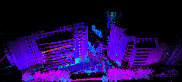
Large-scale point clouds create the geometric foundation for digital twins, progress tracking and retrofit planning across commercial developments.
Distributed assets
Reality capture becomes even more valuable when projects are spread across multiple locations, where maintaining consistent documentation is often one of the biggest operational challenges.
For one customer, Inkers digitized 100 fuel stations across multiple states in India within just 90 days. Completing the same programme using conventional documentation methods would typically have required eight to nine months, with multiple survey teams travelling between sites and producing separate documentation packages.
Instead, every location was captured using the same workflow and integrated into a consistent digital environment. The resulting digital twins provided standardized as-built documentation, enabling owners to compare facilities, plan renovations, support maintenance activities and make investment decisions using reliable site data.
The same workflow also supports office parks, industrial facilities and ageing commercial properties where existing documentation is incomplete or outdated. Rather than beginning each project with new surveys, teams can work from an accurate digital representation that remains available throughout the asset lifecycle.
Thermal diagnostics
Reality capture is not limited to geometry alone.
At a large enterprise facility experiencing persistent water leakage, repeated visual inspections failed to identify the source of the problem. By combining thermal imaging with lidar-based spatial models, Inkers created a digital representation that allowed maintenance teams to locate moisture ingress far more accurately than conventional inspection methods.
Thermal data was captured in one day, with processed outputs delivered within two to three days. Comparable investigations often require two to four weeks, delaying repairs while increasing maintenance costs.
Integrating thermal information into the digital twin allowed maintenance teams to identify problem areas quickly and plan targeted interventions. The result was faster diagnosis, reduced disruption and more efficient maintenance planning.
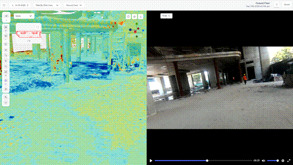
Thermal overlays integrated into the digital twin reveal hidden moisture paths and temperature anomalies, supporting faster diagnosis and more targeted maintenance.
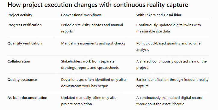
Across its deployments, Inkers reports measurable operational improvements. A single operator can capture approximately 50,000 square feet in 30 minutes, while airport reality capture timelines have been reduced from around 90 days to less than 15 days. Customers have also reported up to 90% lower travel-related site inspection costs and up to 70% lower rework costs through earlier identification of deviations.
Building decisions on better reality
Construction has never lacked information. What many projects have lacked is a reliable way for everyone to work from the same reality.
As digital twins become increasingly important across construction and infrastructure, the quality of the underlying data becomes just as important as the digital model itself. Reliable, repeatable reality capture enables project teams to compare design intent with actual site conditions, identify changes earlier and make decisions based on measurable evidence rather than assumptions.
By combining handheld reality capture, digital twins and Hesai’s XT32 lidar, Inkers helps owners, contractors and engineers build digital representations they can trust. The result is a stronger foundation for planning, construction, operations and long-term facility management, enabling better decisions throughout the entire asset lifecycle.
FAQ
What is a construction digital twin?
A construction digital twin is a continuously updated digital representation of a physical project or asset. Unlike a static BIM model, it evolves as site conditions change, allowing project teams to compare planned and actual progress throughout the asset lifecycle.
Why is lidar important for construction reality capture?
Lidar directly measures three-dimensional geometry, producing accurate point clouds regardless of lighting conditions. This makes it well suited for scan-to-BIM, quantity verification, deviation analysis and the creation of reliable construction digital twins.
What is scan-to-BIM?
Scan-to-BIM is the process of converting lidar point cloud data into Building Information Models (BIM). These models support design validation, renovation planning, construction coordination and facility management.
Why did Inkers choose Hesai’s XT32 lidar?
Inkers selected Hesai’s XT32 because it combines high point cloud density, automotive-grade reliability, compact dimensions and consistent indoor and outdoor performance. These characteristics make it well suited for handheld reality capture, where accurate, repeatable 3D data is essential for digital twins, scan-to-BIM workflows and quantity verification.
How does reality capture help reduce rework?
By comparing captured site conditions with the original design, project teams can identify deviations before downstream work begins. Detecting issues earlier helps reduce rework, improve quality assurance and keep projects on schedule.
What types of projects benefit from construction digital twins?
Construction digital twins are used across commercial developments, airports, industrial facilities, office parks, utilities, infrastructure projects and distributed assets such as fuel station networks. They support planning, construction, operations and long-term asset management throughout the lifecycle of the built environment.